


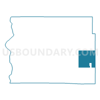
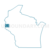
SPRINGFIELD - T 1 Voting District, St. Croix County, Wisconsin
About
Outline

Summary
| Unique Area Identifier | 696868 |
| Name | SPRINGFIELD - T 1 Voting District |
| County | St. Croix County |
| State | Wisconsin |
| Area (square miles) | 34.36 |
| Land Area (square miles) | 34.22 |
| Water Area (square miles) | 0.15 |
| % of Land Area | 99.57 |
| % of Water Area | 0.43 |
| Latitude of the Internal Point | 44.99537290 |
| Longtitude of the Internal Point | -92.20690850 |
Maps

Graphs
Select a template below for downloading or customizing gragh for SPRINGFIELD - T 1 Voting District, St. Croix County, Wisconsin


Neighbors
Neighoring Voting District (by Name) Neighboring Voting District on the Map
- BALDWIN - T 1 Voting District, St. Croix County, WI
- CADY - T 1 Voting District, St. Croix County, WI
- DOWNING - V 1 Voting District, Dunn County, WI
- EAU GALLE - T 2 Voting District, St. Croix County, WI
- EMERALD - T 2 Voting District, St. Croix County, WI
- GLENWOOD - T 1 Voting District, St. Croix County, WI
- LUCAS -T 1 Voting District, Dunn County, WI
- STANTON - T 1 Voting District, Dunn County, WI
- Wilson - V 1 Voting District, St. Croix County, WI
Top 10 Neighboring County Subdivision (by Population) Neighboring County Subdivision on the Map
- Eau Galle town, St. Croix County, WI (1,139)
- Springfield town, St. Croix County, WI (932)
- Baldwin town, St. Croix County, WI (928)
- Emerald town, St. Croix County, WI (853)
- Cady town, St. Croix County, WI (821)
- Stanton town, Dunn County, WI (791)
- Glenwood town, St. Croix County, WI (785)
- Lucas town, Dunn County, WI (764)
- Downing village, Dunn County, WI (265)
- Wilson village, St. Croix County, WI (184)
Top 10 Neighboring Place (by Population) Neighboring Place on the Map
Top 10 Neighboring Unified School District (by Population) Neighboring Unified School District on the Map
- Menomonie Area School District, WI (26,904)
- Baldwin-Woodville Area School District, WI (8,697)
- Boyceville Community School District, WI (4,531)
- Spring Valley School District, WI (4,071)
- Glenwood City School District, WI (4,058)
Top 10 Neighboring State Legislative District Lower Chamber (by Population) Neighboring State Legislative District Lower Chamber on the Map
Top 10 Neighboring State Legislative District Upper Chamber (by Population) Neighboring State Legislative District Upper Chamber on the Map
Top 10 Neighboring 111th Congressional District (by Population) Neighboring 111th Congressional District on the Map
Top 10 Neighboring Census Tract (by Population) Neighboring Census Tract on the Map
- Census Tract 1208, St. Croix County, WI (8,341)
- Census Tract 9702, Dunn County, WI (4,737)
- Census Tract 1207, St. Croix County, WI (4,569)